


Aerial & Satellite Image Annotation: A Complete Guide for Geospatial AI Teams
TL;DR
- Satellite image annotation differs from standard computer vision because it has to preserve coordinate systems, interpret spectral bands, and handle 360-degree object rotation.
- Core annotation types include semantic segmentation, oriented object detection, change detection, and geo-tagging for GIS-native output.
- The real case for outsourcing this work isn't volume. It's the QC infrastructure and domain-trained annotators most in-house teams can't build fast enough.
- Resolution mismatch between training and inference data is the most common cause of geospatial model failure.
- TaskMonk's platform supports GeoPackage import/export, GeoJSON-native output, and SAM-based segmentation built for satellite and aerial imagery at scale.
Most teams treat satellite image annotation as regular image annotation with a different camera angle. That assumption is exactly why so many geospatial models perform well in validation and then fail once they hit real deployment conditions.
The reasoning makes sense on the surface. A polygon is a polygon, a bounding box is a bounding box, and an annotator who can label a street scene should be able to label a field boundary. But overhead imagery breaks that logic in ways that don't show up until the model is already in production: objects rotate through 360 degrees instead of sitting upright, a single pixel can represent 100 square meters of ground instead of a few centimeters, and the annotation itself needs to carry a coordinate reference system all the way through export or it's useless in a GIS stack.
This guide covers what actually makes aerial and satellite annotation different from standard computer vision, the annotation types and technical requirements that decide whether a model generalizes past the region it was trained on, and the actual case for using a specialized geospatial data annotation service instead of building this in-house, including what to check before you commit budget to a provider.
Here's how it actually works.
What is aerial and satellite image annotation?
Aerial and satellite image annotation is the process of labeling objects, boundaries, and land features in overhead imagery so a machine learning model can learn to recognize them on its own. That means drawing polygons around field boundaries, placing bounding boxes on vehicles or vessels, marking pixel-level land cover classes, or flagging what changed between two dates of the same location.
The output looks similar to standard image annotation on the surface: labeled shapes over pixels. What's different is what those labels have to carry. A bounding box on a street-level photo just needs to be roughly the right size and position. A bounding box on a satellite frame needs to preserve a rotation angle, sit inside a coordinate reference system, and often needs to match a specific ground sample distance so the model can generalize to imagery captured by a different sensor later.
For a deeper look at how this fits into the broader drone and satellite imagery annotation landscape, including modality-specific tooling, see our full guide.
Aerial, drone, and satellite imagery: what's different, and why it matters
These three data sources get lumped together constantly, and that's where a lot of annotation programs go wrong. Drone imagery is typically captured at low altitude, at sub-centimeter resolution, with the platform's own GPS metadata attached. Aerial imagery, usually from fixed-wing aircraft, sits in between: wide coverage with resolution fine enough for infrastructure and vegetation detail. Satellite imagery ranges from sub-meter commercial sources like WorldView and SkySat down to the 10 to 30 meter resolution of Sentinel-2 and Landsat, covering far larger areas per frame.
The gap matters because annotation guidelines that work for one don't transfer cleanly to another. A polygon boundary standard built for centimeter-level drone footage of a construction site will produce noise, not signal, when applied to 10-meter land cover tiles where a single pixel already represents a 100 square meter area. Teams that write one spec for "overhead imagery" and apply it across all three sources end up with inconsistent labels and a model that can't tell why its accuracy drops when the input source changes.
Pro tip: Before writing your annotation spec, decide which platform your production inference data will actually come from. Annotate to match that resolution and sensor type first, and treat other sources as secondary training data, not equals.
Why geospatial annotation is different from standard computer vision
Three things separate this from labeling street-level photos or product images.
Objects don't have a fixed orientation. A car photographed from the ground always has a "front" facing some direction relative to the camera. From directly overhead, that same car could be rotated anywhere across 360 degrees, and standard axis-aligned bounding boxes waste pixels or clip the object entirely. Detection frameworks built for satellite work, like those using rotated or oriented bounding boxes, need annotations that capture the rotation angle as a first-class value, not an afterthought.
Coordinate systems have to survive the entire pipeline. An annotation that looks correct on screen but loses its link to WGS84 or a UTM projection during export is functionally useless for a GIS-native workflow. The annotator drew the right shape in the right place, but if that shape doesn't map back onto the Earth's surface when it lands in QGIS or ArcGIS, the client has to manually rebuild spatial references, which defeats the point of outsourcing the work.
Annotators are often labeling data humans can't naturally see. Multispectral and SAR imagery require interpreting near-infrared, shortwave infrared, or radar backscatter, not visible color. A forest that looks fine in RGB can show clear stress in NIR. Annotators without training in spectral signatures will label based on what looks normal, not what the data actually shows, and that error compounds across every image they touch.
Core annotation types for aerial and satellite imagery
Most geospatial projects draw from a handful of annotation types, each suited to a different modeling goal.
Semantic segmentation for land cover and boundaries. Pixel-level classification across large tiles, used for crop type mapping, land use classification, and coastline tracking. Boundary quality matters more than volume here: sloppy edges at tile borders propagate directly into the model's learned boundaries.
Object detection with rotation-aware bounding boxes. Used for vehicle counting, ship detection, and infrastructure identification. Since targets can appear at any angle, the annotation format has to capture orientation, not just position and size.
Change detection between image pairs. Two images of the same location at different times, with a change mask marking what's new, removed, or altered. This needs annotators to keep temporal consistency, so the same feature doesn't get labeled inconsistently across dates, and often needs semantic distinction between change types like "newly built" versus "demolished."
Geo-tagged polygon and polyline annotation. Structured output for roads, field boundaries, and points of interest, exported in GeoJSON or shapefile format for direct use in a GIS stack. This is where format fidelity, not just labeling accuracy, decides whether the deliverable is usable on day one.
Pro tip: If your pipeline includes both segmentation and change detection on the same imagery, annotate them as separate passes with separate QA. Combining them in one workflow tends to produce segmentation masks that are technically correct but inconsistent across time, since the annotator's attention splits between two different judgment calls.
Industries and use cases
Aerial and satellite annotation shows up wherever an organization needs to understand the physical world at scale without sending people to look at it directly.
- Agriculture: field boundary mapping, crop type classification, and vegetation health monitoring using NDVI-derived spectral bands
- Urban planning and infrastructure: building footprint extraction, road network mapping, and construction progress tracking
- Insurance: post-disaster damage assessment, comparing pre- and post-event imagery to flag affected structures
- Environmental monitoring: deforestation tracking, wetland loss, and coastline erosion over multi-year time series
- Defense and maritime intelligence: vessel detection, port activity monitoring, and SAR-based surveillance that works through cloud cover
- Energy and utilities: solar and wind site monitoring, pipeline right-of-way inspection, and vegetation encroachment on transmission lines
Robotics and autonomous systems teams working with drone footage specifically will find overlap with video annotation for autonomous systems, particularly around object tracking across frames.
Technical requirements that make or break geospatial annotation
Resolution mismatch is the single most common reason a geospatial model fails outside its training conditions. Train on 10-meter Sentinel-2 tiles and deploy against 0.5-meter commercial imagery, and accuracy doesn't degrade gracefully. It falls off a cliff, because the model learned features at a scale that no longer exists in the input.
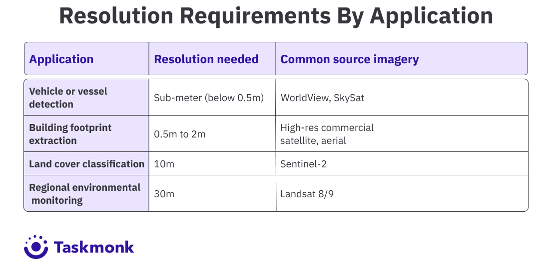
Beyond resolution, three edge cases quietly degrade most production geospatial models: cloud and shadow contamination that annotators need to distinguish rather than mislabel as clear ground, off-nadir capture angles that change both geometry and apparent resolution, and geographic domain shift, where a model trained on one region's imagery loses significant accuracy when deployed against a visually different geography. A spec that doesn't explicitly cover these cases will produce a dataset that looks complete and trains a model that isn't.
How expert annotation ensures quality
Quality control for geospatial data needs a different bar than general object detection, where 0.5 IoU often passes as acceptable. Production geospatial systems, especially for infrastructure monitoring or anything feeding a downstream business decision, typically need 0.85 to 0.9+ IoU before the labels can be trusted.
Getting there takes more than a single annotator's best effort. Multi-stage review, where a second set of eyes checks polygon boundaries and class assignments before delivery, catches the boundary drift and staircase artifacts that a single pass misses. Calibration before production work, where annotators have to hit an accuracy threshold on known-answer tasks before touching real data, filters out the annotators who haven't internalized the domain's visual patterns yet. And ongoing accuracy tracking, not just a one-time check, catches quality drift as a project scales from a pilot batch to full production volume.
Format integrity is part of quality too, not a separate concern. A polygon that's spatially perfect but loses its coordinate reference system on export creates just as much rework as a badly drawn boundary. Teams evaluating a provider should ask to see a sample delivery loaded directly into QGIS or ArcGIS before committing to volume, not just a screenshot of the annotation interface.
This is also where a service provider's operational maturity actually shows up. Calibration, multi-stage review, and accuracy tracking need to be built into the delivery process by default, not improvised project by project. That difference is usually invisible in a sales conversation and very visible three months into a production contract.
How AI-assisted labeling and foundation models speed up geospatial annotation
Foundation models have changed the economics of geospatial annotation, but not in the way "fully automated" pitches suggest. Segmentation models built on the SAM architecture can generate an initial polygon boundary from a single point click, cutting the manual drawing time on land cover and building footprint work substantially. Object detection models pretrained on aerial and satellite datasets can pre-label vehicles, structures, and vessels before a human ever opens the image.
The practical workflow looks like this: a model generates a rough label, a trained annotator corrects the boundary and fixes what the model got wrong, and QC validates the final output against the accuracy threshold for that project. What foundation models still get wrong consistently: cloud versus cirrus haze, greenhouse structures that read as buildings, and any feature that's rare enough that the pretraining data barely saw it. Skipping the human correction step on those cases means training a model on the foundation model's own blind spots.
Pro tip: Run a small pilot batch through pre-labeling before committing to it at scale. If the pre-label accuracy on your specific feature types is below roughly 70%, the correction overhead can end up costing more time than annotating from scratch.
Why choose expert annotation services (and how to choose a provider)
Most teams don't need to be convinced that geospatial data needs specialized handling. What they actually need is a clear answer to a budget question: is this worth building in-house, or does it make more sense to hand it to a service that's already built the infrastructure for it.
The build-versus-buy math usually comes down to three costs teams underestimate when they price out an in-house team. Domain-trained annotators for geospatial work take longer to hire and ramp than general image labelers, since spectral band interpretation and coordinate reference system handling aren't skills most annotators walk in with. QC infrastructure, calibration testing, inter-annotator agreement tracking, golden data validation, is a separate build from the labeling tool itself, and most in-house teams underinvest in it until a bad batch forces the issue. And volume is rarely steady: a team sized for a 50,000-image pilot sits idle for months, then can't scale fast enough when a production dataset lands. A specialized annotation service absorbs that volatility. An in-house team, in most cases, can't.
Once you've decided a service makes sense, the harder part is telling a provider that actually has geospatial expertise from one applying generic image annotation workflows to satellite data and hoping the terminology transfers. Ask for a sample delivery that includes real geospatial output, not a demo screenshot. Load it into your own GIS stack and check whether the coordinate reference system survived the export. Ask what QC method the provider uses on tasks like yours, and whether that method changes based on task difficulty or stays fixed regardless of volume. Ask how they handle disagreement between annotators on ambiguous cases like cloud shadow versus a genuinely dark surface feature, since the answer says a lot about whether their QC process is designed for real-world image conditions or a controlled benchmark.
A provider worth working with should also be upfront about what they're not the right fit for. If your project is small, under a few hundred images, or covers a narrow, highly specialized feature type with almost no precedent, a lighter-weight or in-house approach might genuinely serve you better than an enterprise annotation program built for continuous, high-volume delivery. TaskMonk's platform is built for teams running geospatial annotation as an ongoing pipeline, not a one-off batch: if that's not your situation yet, it's worth saying so before a pilot starts.
Data security and compliance for sensitive geospatial data
Geospatial data carries its own sensitivity profile. Infrastructure imagery, defense-adjacent surveillance data, and property-level detail all raise questions that generic image datasets don't. A provider handling this data at enterprise scale needs role-based access control by default, encrypted storage and transfer, and the ability to keep data inside a dedicated environment rather than a shared multi-tenant pipeline when the project calls for it.
TaskMonk's infrastructure is built on this standard: SOC 2 Type I certification covering security, confidentiality, and availability with annual audits, alongside ISO 27001 and HITRUST certification. Data can render directly from a client's own database without landing on TaskMonk's servers, and on-premise or dedicated VPC deployment is available for projects where data residency is a hard requirement, not a preference. Multi-factor authentication is enforceable org-wide by an administrator, and every employee goes through documented security training and background checks before touching client data.
For teams evaluating vendors on compliance specifically, ask whether these certifications are current and whether on-premise deployment is a real option or a roadmap item. The difference matters more in geospatial work than in most other annotation categories, given how often the underlying imagery touches critical infrastructure or defense-adjacent use cases.
Our annotation process (from pilot to production)
Most geospatial annotation programs fail quietly in the handoff between pilot and production, not in the pilot itself. A small batch gets careful attention, looks great, and then quality drifts once volume scales and the same rigor doesn't carry through. TaskMonk's process is built to hold that line as volume grows, not just at the start.
Native geospatial format support. TaskMonk's geo-tagging workspace supports native GeoPackage (GPKG) import and export, including pre-annotations, and produces GeoJSON-standard output with FeatureCollection and LineString or Polygon geometries. That means annotations land in your GIS stack without a manual reformatting step, which is where a lot of providers quietly lose fidelity.
Orthogonalise and multi-provider base maps. The platform's orthogonalise tool snaps hand-drawn polygons to right angles automatically, which matters for building footprints and infrastructure boundaries where a slightly skewed edge compounds across a dataset. Annotators can work against Google Maps, Esri, or OpenStreetMap base layers depending on what the project needs, with a representative scale selector for measurement accuracy against real-world distance.
SAM-based one-click segmentation. TaskMonk's Segment Anything integration, upgraded to SAM-3, gives a single-point click a full object boundary, cut down further by YOLO v12 for pre-annotation on object detection tasks. Combined with the platform's Golden Data system, where blind ground-truth tasks are interleaved into normal allocation to produce a running Golden Accuracy score, teams get both speed and a live accuracy signal without waiting for a full batch to complete.
Configurable QC that scales with volume. DynamicPercentageRule routes tasks to QC review based on an individual annotator's rolling accuracy, meaning high performers earn lighter review while lower performers get closer oversight, automatically, without a project manager manually reassigning work as volume grows.
TaskMonk has processed 480M+ tasks and 6M+ labeling hours across its platform, supports 10+ Fortune 500 client teams, and holds a 4.6 out of 5 rating on G2. If you want to see how the geospatial workflow performs against your own imagery, book a pilot with the TaskMonk team and run a real batch through before committing to volume.
Conclusion
The cost of getting geospatial annotation wrong doesn't show up on delivery day. It shows up months later, when a model that scored well in validation starts failing quietly against imagery from a new region or a different sensor, and nobody can point to a single bad label that explains why.
The teams who avoid this treat geospatial annotation as its own discipline from the start: matching resolution to deployment conditions, preserving coordinate systems through the entire pipeline, and building QC around IoU thresholds that match what the model actually needs in production, not the defaults that work for street-level object detection.
Annotation quality is infrastructure, not a line item. Build it like the model's accuracy depends on it, because it does.
Frequently Asked Questions
What's the difference between aerial and satellite image annotation?
Aerial imagery is typically captured from aircraft or drones at higher resolution and lower altitude, while satellite imagery covers larger areas at resolutions ranging from sub-meter commercial sources to 10-30 meters for sources like Sentinel-2 and Landsat. The annotation principles overlap, but the spec needs to account for the resolution and coverage difference. A boundary standard built for centimeter-level drone footage won't transfer cleanly to a 10-meter land cover tile.
How much does satellite image annotation cost?
It depends heavily on annotation type and volume. Semantic segmentation on large tiles runs more expensive per image than simple bounding box detection because of the pixel-level precision required. Change detection projects cost more than single-image annotation since they need paired, temporally consistent labeling. Most providers price by task complexity and volume rather than a flat per-image rate, so get a quote based on your actual annotation type and expected throughput rather than comparing generic per-image prices across vendors.
Should I build an in-house team or outsource satellite image annotation?
Outsource unless annotation is a permanent, large-scale function that's genuinely core to your product. Building in-house means hiring and training domain-specific annotators, building QC infrastructure from scratch, and carrying the cost of idle capacity between projects. A specialized geospatial annotation service gets you calibrated annotators and existing QC infrastructure faster, and the cost scales with actual volume instead of headcount. In-house makes more sense when your annotation guidelines change constantly or your taxonomy is proprietary enough that handing it to an outside team creates more overhead than it saves.
Can AI or foundation models fully automate satellite image annotation?
Not for anything where accuracy matters in production. Foundation models like SAM-based segmentation cut manual labeling time significantly for routine boundary work, but they still miss edge cases: cloud versus cirrus haze, greenhouse structures misread as buildings, and rare feature types the pretraining data barely covered. Most reliable pipelines use model-generated pre-labels with human correction and QC validation, not fully automated output.
What annotation accuracy should I expect for a production geospatial model?
Production systems generally need 0.85 to 0.9+ IoU, well above the roughly 0.5 IoU that passes as acceptable in general computer vision object detection. Getting there requires multi-stage review, calibration thresholds annotators have to hit before touching production data, and ongoing accuracy tracking as volume scales, not just a one-time quality check on the first batch delivered.
Do I need annotators with GIS or remote sensing experience?
For anything beyond basic object detection, yes. Annotators working with multispectral or SAR imagery need training in spectral signatures and band interpretation, since they're often labeling data that doesn't look normal to the naked eye. Annotators unfamiliar with coordinate reference systems are also more likely to produce labels that look correct on screen but lose their spatial accuracy on export, which creates rework downstream.

.png)
