We did the heavy lifting in 2025. Here’s what it
added up to ->
View Details.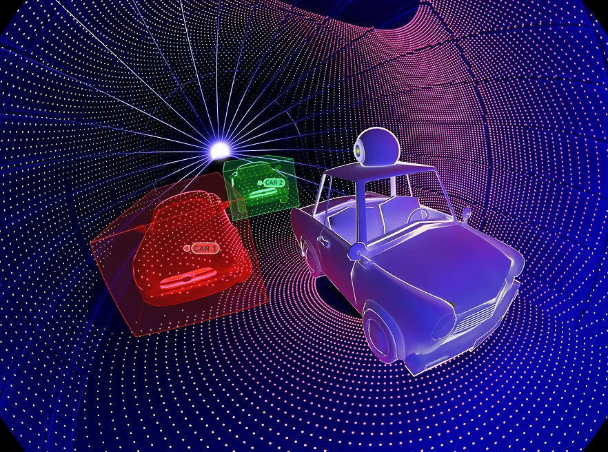
Enterprise LiDAR annotation platform to streamline 3D LiDAR and geospatial data labeling,
enabling perception teams to quickly produce high-accuracy, production-ready datasets for real-world applications.
TALK TO OUR EXPERTS
Advanced features for LiDAR annotation
Purpose-built toolkit to scale 3D LiDAR annotation across physical environments. Enables AI teams to accelerate point-cloud dataset delivery by integrating multi-sensor fusion, AI assistance, quality assurance, and workflows—providing faster, production-ready results.
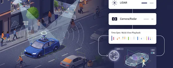
Multi-sensor Fusion & Calibration
Unify LiDAR with camera/radar in one workspace. Handle extrinsics/intrinsics, time sync, and multi-view playback so 3D LiDAR annotation stays consistent across sequences, scenes, and lighting conditions, which boosts the point-cloud accuracy.
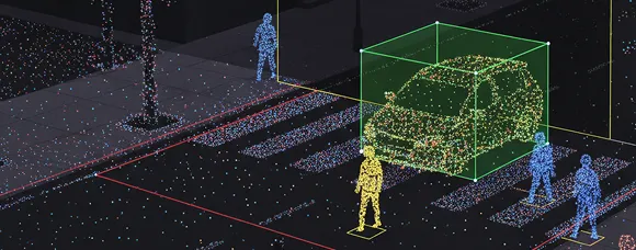
3D Tools & Visualization for Point-Clouds
Utilize 3D cuboids, polylines, polygons, keypoints, and semantic segmentation for annotation. Adjusting point size,intensity, or height coloring, clipping, and class layers accelerates precise point cloud annotation across complex environments.
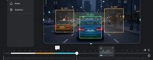
Sequences, Object Tracking & Timeline Ops
Track objects with stable IDs across frames, scrub long drives, and bookmark edge cases. Maintain versioned edits and per-frame notes to organize annotation, while analytics highlight blockers before they impact SLAs.
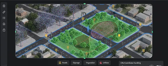
Geospatial & Mapping
Bring geospatial annotation into LiDAR workflows with CRS/coordinate handling (e.g., WGS84/EPSG), base maps/tiles, and asset tagging for roads, signage, vegetation, and utilities in city, aerial/drone, and infrastructure datasets.
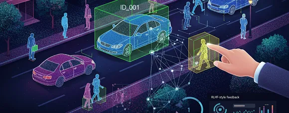
AI Assist & Human-Feedback Loops
Accelerate 3D LiDAR annotation with pre-labels that labelers approve or correct. Persist IDs between frames, interpolate keyframes, route low-confidence via active-learning, and standardize reviews with gold tasks, rubrics, and RLHF-style feedback.
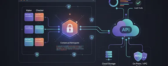
Quality, Governance & Secure Pipelines
Maker–checker, consensus/honeypots, and programmatic rules checks with per-class KPIs and audit trails. Export clean versions via APIs and cloud storage integrations, with RBAC and on-prem/VPC options for enterprise control.
Use cases for LiDAR annotation
Proven workflows for 3D LiDAR annotation and geospatial annotation across road, aerial, and indoor physical environments. Advance pilots to production with QA and export-ready datasets.

Autonomous driving & ADAS perception
Use 3D LiDAR annotation with sensor fusion to label detection, tracking, and segmentation across long driving sequences, producing robust perception datasets that reduce false positives and improve real-world performance.

HD mapping & smart-city assets
Create high-fidelity maps by annotating lanes, curbs, signs, street furniture, façades, trees, and utilities; version updates and export layers to support digital twins, traffic engineering, and urban planning workflows.

Aerial/drone mapping & inspection
Scale geospatial annotation on UAV or helicopter LiDAR for infrastructure, agriculture, and disaster assessment; extract features, run change detection, and prioritize maintenance or response with audit-ready outputs.

Energy & utilities (vegetation & asset health)
Label towers, spans, and components, detect vegetation encroachment and clearance risks, and generate actionable reports that feed preventive maintenance, compliance checks, and field work orders.

Robotics, warehousing & indoor safety
Annotate racks, pallets, equipment, vehicles, and human zones within complex physical environments to improve SLAM, obstacle avoidance, and collision prevention while maintaining accurate object IDs across time.
Autonomous driving & ADAS perception
Use 3D LiDAR annotation with sensor fusion to label detection, tracking, and segmentation across long driving sequences, producing robust perception datasets that reduce false positives and improve real-world performance.
HD mapping & smart-city assets
Create high-fidelity maps by annotating lanes, curbs, signs, street furniture, façades, trees, and utilities; version updates and export layers to support digital twins, traffic engineering, and urban planning workflows.
Aerial/drone mapping & inspection
Scale geospatial annotation on UAV or helicopter LiDAR for infrastructure, agriculture, and disaster assessment; extract features, run change detection, and prioritize maintenance or response with audit-ready outputs.
Energy & utilities (vegetation & asset health)
Label towers, spans, and components, detect vegetation encroachment and clearance risks, and generate actionable reports that feed preventive maintenance, compliance checks, and field work orders.
Robotics, warehousing & indoor safety
Annotate racks, pallets, equipment, vehicles, and human zones within complex physical environments to improve SLAM, obstacle avoidance, and collision prevention while maintaining accurate object IDs across time.
LiDAR annotation workflow
Workflow that standardizes 3D LiDAR annotation and geospatial annotation across environments.

Configure & Ingest
First, define classes and attributes. Then, import single scans or long sequences from S3, GCS, or Azure. Taskmonk keeps calibration, timestamps, and ego-odometry for accurate fusion and review.
.svg)
Calibrate & Align
Run a gold-set sprint and set rubrics for occlusion, truncation, merging or splitting, and temporal rules. Turn these into clear execution policies to standardise 3D LiDAR and geospatial annotation.
.svg)
Assist & Track
Use Taskmonk Assist for pre-labeling, propagation, and interpolation. Keep object IDs stable across frames. Flag edge cases and version edits to keep a clear change history.

Review & Ship
Apply maker–checker and programmatic checks. Monitor KPIs for each class. Export JSONL or custom files via API and storage connectors, with role-based security and audit trails.
Configure & Ingest
First, define classes and attributes. Then, import single scans or long sequences from S3, GCS, or Azure. Taskmonk keeps calibration, timestamps, and ego-odometry for accurate fusion and review.
Calibrate & Align
Run a gold-set sprint and set rubrics for occlusion, truncation, merging or splitting, and temporal rules. Turn these into clear execution policies to standardise 3D LiDAR and geospatial annotation.
Assist & Track
Use Taskmonk Assist for pre-labeling, propagation, and interpolation. Keep object IDs stable across frames. Flag edge cases and version edits to keep a clear change history.
Review & Ship
Apply maker–checker and programmatic checks. Monitor KPIs for each class. Export JSONL or custom files via API and storage connectors, with role-based security and audit trails.
Security and compliance you can rely on
Protect LiDAR and point-cloud data with enterprise controls that satisfy security teams without slowing delivery. Taskmonk provides identity, access, network, and data protections.
.svg)
Enterprise-grade security
Data is encrypted in transit and at rest, with SSO/SAML + MFA, granular RBAC, and customer-managed keys via cloud KMS.

.avif)
Compliance built in
Controls map to SOC 2 Type, ISO 27001, and GDPR. Immutable audit trails provide comprehensive coverage of views, edits, exports, and administrative actions for full traceability.
.svg)
Flexible deployment
Run in your Virtual Private Cloud or on-premises. Choose cloud regions for data residency, and use private endpoints with IP allowlists.

Zero-copy access
Keep datasets in your own storage buckets. Taskmonk reads and writes in place via signed URLs or temporary credentials—no unmanaged duplicates, with clear retention and deletion Service Level Agreements.
Enterprise-grade security
Data is encrypted in transit and at rest, with SSO/SAML + MFA, granular RBAC, and customer-managed keys via cloud KMS.
Compliance built in
Controls map to SOC 2 Type, ISO 27001, and GDPR. Immutable audit trails provide comprehensive coverage of views, edits, exports, and administrative actions for full traceability.
Flexible deployment
Run in your Virtual Private Cloud or on-premises. Choose cloud regions for data residency, and use private endpoints with IP allowlists.
Zero-copy access
Keep datasets in your own storage buckets. Taskmonk reads and writes in place via signed URLs or temporary credentials—no unmanaged duplicates, with clear retention and deletion Service Level Agreements.
Why trust Taskmonk for LiDAR annotation projects.
Battle-tested LiDAR and point-cloud annotation with secure, compliant, scalable workflows—built for long sequences, multi-sensor data, and enterprise governance.
Proven at scale
Handled 200M+ tasks and 5M+ labeling hours with 99.9% uptime. Supports long drives, aerial surveys, and complex scenes with steady results and tracked changes.
Trusted by enterprise AI teams
Used by autonomy, robotics, mapping, and utilities teams. Controls meet SOC 2 and GDPR. Security features and data residency support internal reviews.
Measurable outcomes
AI assistance, propagation, and interpolation streamline workflows and minimize rework. Per-class KPIs, IAA, and targeted QA boost agreement and model performance.
Reliable delivery
VPC/on-prem options, private endpoints, and zero-copy access enforce data governance. APIs, SDKs, webhooks, and connectors keep pipelines efficient and schedules reliable.
Expert labeling services for LiDAR
Scale faster with a vetted workforce trained on LiDAR, 3D point clouds, camera/radar, and geospatial data
TALK TO OUR EXPERTS
End-to-end project management
We scope tasks, finalize guidelines, establish workflows, and conduct QA throughout delivery. With one owner, weekly SLAs, and transparent dashboards, we keep your schedule on track.
Multimodal data annotation expertise
LiDAR, camera, and radar data are integrated into a single workspace. Our teams manage sequences, tracking, and edge cases with consistent decisions.
Secure, scalable, cost-predictable
We offer SSO/RBAC, VPC/on-prem options, and zero-copy access to your buckets. Our scalable pods and clear rates mean no hidden fees.
Proof of concept
Start with a POC—limited classes and sequences, measurable KPIs, and a go/no-go review—so you can de-risk scope before full rollout.
FAQ
What is LiDAR annotation?
LiDAR annotation labels 3D point cloud data so that models can detect, track, and segment objects and surfaces. Tasks include drawing 3D cuboids, polylines, polygons, and segmenting by type or instance, often using sensor fusion and strict QA.
Which point cloud annotation types do you support for 3D LiDAR annotation?
3D cuboids (vehicles, pedestrians, assets), polylines (lane markers, curbs), polygons (drivable areas), keypoints (articulated parts), and semantic/instance segmentation. Class attributes, hierarchy, and occlusion/truncation rules enforce consistency across sequences.
Do you support sensor fusion annotation for LiDAR, using a camera or radar?
Yes. Calibrated extrinsics and intrinsics, along with time synchronization, enable overlaid or side-by-side views. Reviewers validate geometry against images, maintain stable IDs across frames, and use propagation/interpolation to accelerate multi-sensor sequences.
How is a LiDAR annotation tool different from other tools?
A LiDAR annotation tool is built for true 3D at scale: large point-cloud loading, intensity/height coloring, clipping, and timeline operations. It preserves calibration/ego-motion, supports long sequences with tracking, and provides QA, audit trails, and clean exports for MLOps.
What does a typical LiDAR POC include, and how long does it take?
A POC narrows the schema and selects representative sequences, sets KPIs (quality, IAA, cycle time), runs a calibration sprint, and measures assisted labeling and QA. Most teams reach a go/no-go decision within a few weeks, then scale the same workflow.
How do you ensure LiDAR annotation quality at scale?
Start with clear guidelines and gold tasks, then enforce maker–checker reviews and programmatic geometry/rules checks. Track per-class KPIs, IAA, and rework in dashboards; route low-confidence frames to review and continuously update rubrics and assist models.
Request a live walkthrough of visualization, labeling, QA, and export pipelines.