We did the heavy lifting in 2025. Here’s what it
added up to ->
View Details..webp)
High-quality ground truth labels for satellite, drone, and LiDAR models to power mapping, monitoring, and change detection.
TALK TO OUR EXPERTS
Capabilities of Taskmonk's geospatial data labeling
From satellite imagery annotation to LiDAR labeling, we deliver geospatial training data that performs reliably in real-world production and improves model stability.
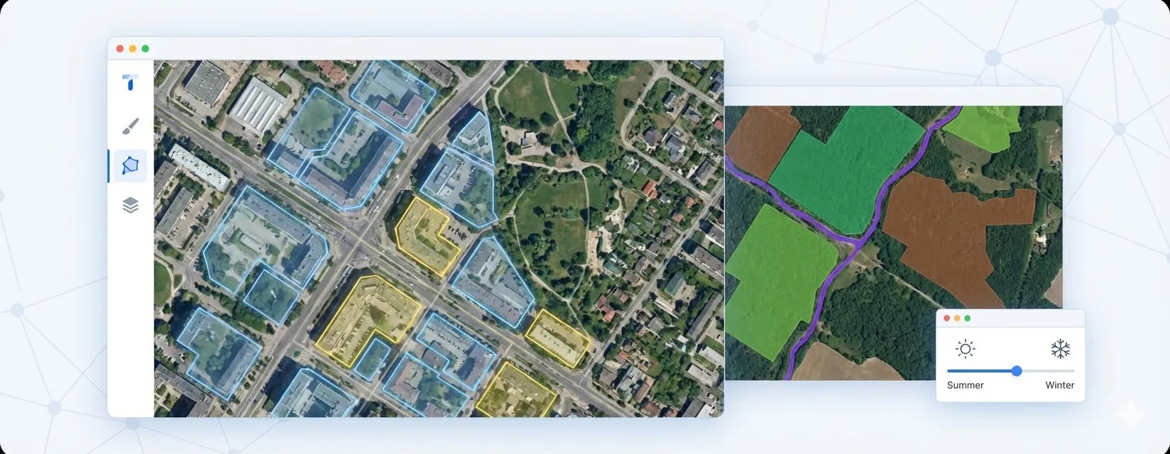
Satellite imagery annotation
We provide polygon and segmentation labels for buildings, roads, land cover, and critical infrastructure, ensuring remote sensing models remain accurate across tiles, regions, and seasons.
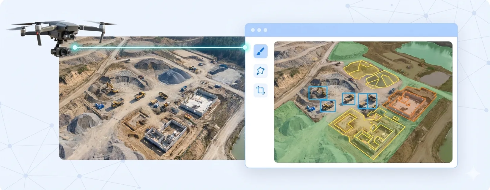
Drone and aerial image labeling
We create high-resolution bounding boxes, polygons, and masks for inspection, construction, mining, and site monitoring, and follow consistent guidelines to reduce edge-case errors in real-world deployments.
.webp)
LiDAR point cloud annotation
LiDAR annotation for 3D cuboids and point-level segmentation of vehicles, pedestrians, terrain, and obstacles, built for navigation and perception workflows where spatial accuracy and class consistency matter.
GIS, vector, and change detection labeling
We label polylines and boundaries for parcels, roads, and utilities, and apply time-series change tags for damage, growth, and compliance, ensuring deliveries include attributes and topology checks.
Geospatial data annotation use cases
Production-ready geospatial training data for mapping, monitoring, and change detection across satellite imagery, GIS, and LiDAR.

Urban Planning
Polygon and segmentation labels for buildings, parcels, and land use that keep city-scale mapping accurate across tiles, regions, and seasonal shifts in imagery.
.svg)
Autonomous Vehicles
Point-level segmentation and 3D object labels for terrain, obstacles, vehicles, and pedestrians, built for perception pipelines where spatial precision drives safety.

Agriculture
Annotate fields, crop areas, and vegetation patterns to enable yield estimation and risk scoring, even when imagery includes haze, shadows, and mixed pixels.

Disaster Response
Label flood extent, debris, and structural damage to support response and recovery planning, using consistent time-series ground truth across before and after imagery.
.svg)
Mapping and Navigation
Create polyline and segmentation labels for roads, trails, and intersections to improve routing reliability, connectivity graphs, and navigation performance across changing terrain.

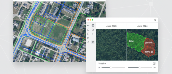
Environmental Monitoring
Before-and-after labels to track deforestation, growth, degradation, and compliance events, with review rules that reduce false changes from lighting and seasonality.
Urban Planning
Polygon and segmentation labels for buildings, parcels, and land use that keep city-scale mapping accurate across tiles, regions, and seasonal shifts in imagery.
Autonomous Vehicles
Point-level segmentation and 3D object labels for terrain, obstacles, vehicles, and pedestrians, built for perception pipelines where spatial precision drives safety.
Agriculture
Annotate fields, crop areas, and vegetation patterns to enable yield estimation and risk scoring, even when imagery includes haze, shadows, and mixed pixels.
Disaster Response
Label flood extent, debris, and structural damage to support response and recovery planning, using consistent time-series ground truth across before and after imagery.
Mapping and Navigation
Create polyline and segmentation labels for roads, trails, and intersections to improve routing reliability, connectivity graphs, and navigation performance across changing terrain.
Environmental Monitoring
Before-and-after labels to track deforestation, growth, degradation, and compliance events, with review rules that reduce false changes from lighting and seasonality.
Geospatial data annotation workflow
A repeatable geospatial data labeling workflow that locks guidelines early and scales cleanly through production QA.
Pilot and feasibility check
To start, we run a small pilot on your geospatial sample data to validate classes, edge cases, output formats, and acceptance criteria before starting work.
Guidelines and label taxonomy
We finalize a clear taxonomy, attribute schema, and edge-case rules so every annotator labels consistently across regions, sensors, seasons, and tile boundaries.
Geospatial data labeling sprints
Work is shipped in planned batches with daily throughput tracking, issue flags, and quick feedback loops, keeping timelines predictable while maintaining annotation consistency.
QA, review, and corrections
Multi-pass review with sampling plans, gold sets, and topology checks catches boundary noise, duplicates, and class confusion before your dataset is approved.
Delivery and versioned exports
You receive clean exports with metadata and dataset versions, making it easy to retrain, compare experiments, and audit what changed across releases.
Continuous improvement loop
We monitor recurring failure modes, update guidelines, and tune QA checks, so label quality improves over time as your model and data evolve.

Reliable delivery you can plan around
In addition to reliable delivery, clear sprints, predictable handoffs, and versioned exports keep your training data on schedule. Dedicated review steps and process adjustments ensure the quality of production data.

Access to the best data labelers
Domain-vetted annotators follow strict guidelines and edge-case playbooks, producing high-quality ground truth labels that hold up in real-world production.

Data security built in
Safeguard your sensitive geospatial data—request a security assessment to meet your program’s requirements.
Reliable delivery you can plan around
In addition to reliable delivery, clear sprints, predictable handoffs, and versioned exports keep your training data on schedule. Dedicated review steps and process adjustments ensure the quality of production data.
.svg)
Access to the best data labelers
Domain-vetted annotators follow strict guidelines and edge-case playbooks, producing high-quality ground truth labels that hold up in real-world production.
Data security built in
Safeguard your sensitive geospatial data—request a security assessment to meet your program’s requirements.
Geospatial data labeling services with expert execution services from Taskmonk
Selectively trained geospatial data annotators and QA workflows help you scale satellite, drone, GIS, and LiDAR labeling projects reliably.
Geospatial project management
Scope and design classes, receive weekly deliveries, and collaborate with a dedicated contact through a documented workflow that keeps production moving.
Geospatial labeling expertise
Leverage teams experienced in polygons, polylines, masks, point clouds, and change detection, using gold sets and edge-case rules for label consistency across tiles and regions.
Secure, scalable, cost-predictable
Rely on access controls, audit logs, and optional restricted environments, with transparent reporting on throughput, quality, and rework for confident planning.
Fast proof of concept
Share a sample dataset and label spec, and we'll return labeled examples with a QA snapshot so you can validate the fit before scaling to production.
FAQ
What is geospatial data annotation?
Geospatial data annotation is the process of labeling location-based datasets, such as satellite imagery, drone imagery, GIS vector layers, and LiDAR point clouds, so that machine learning models can learn to perform mapping, monitoring, and navigation tasks accurately.
Which annotation types are most common for satellite imagery annotation?
Most projects use polygons and segmentation masks for buildings and land cover, polylines for roads and rivers, points for landmarks, and classification and attribute tagging to produce richer geospatial training data.
What geospatial formats do you support for input and output?
Common inputs include GeoTIFF and Cloud Optimized GeoTIFF (COG), tiled imagery, multispectral imagery, LiDAR point clouds, and GIS vector layers. Outputs include GeoJSON, segmentation masks, vector polygons and polylines, plus metadata.
How do you ensure quality in geospatial annotation at scale?
We use clear labeling guidelines, edge-case playbooks, multi-pass QA, gold sets, and topology checks to prevent broken polygons, duplicate features across tiles, and class drift across regions and seasons.
How do we start a geospatial data annotation pilot with Taskmonk?
Share a small sample dataset, label taxonomy, and target outputs. We return labeled examples with a QA snapshot and a scale plan, then move into production sprints with predictable deliveries.
Start with a 24-48h pilot for geospatial data annotation and validate quality before scaling.